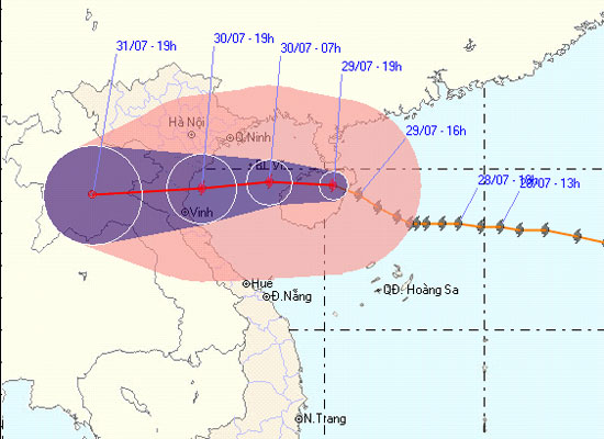
Tin storm No. 3, night 29/7
At 19:00 on July 29, the location of the center of the storm was about 19.5 degrees North latitude; 110.3 degrees Kinh Dong, about 490 km away from the coast of Thai Binh - Ha Tinh to the Southeast. The strongest wind in the area near the storm center is strong at level 10 (ie from 89 to 102 km per hour), level 11 and level 12 jerks.

It is forecasted that in the next 24 hours, the storm will move mainly in the West, about 20km per hour. By 19:00 on July 30, the location of the center of the storm was about 19.4 degrees north latitude; 106.2 degrees Kinh Dong, on the coastal areas of Thai Binh - Ha Tinh provinces. The strongest winds in the area near the storm center are strong at level 9, level 10 (ie from 75 to 102 km per hour), level 11 and level 12 jerks.
In the next 24 to 48 hours, the storm moved in the direction between West and Southwest Southwest, about 15km each hour, went to the mainland and weakened into a low pressure area. By 19:00 on July 31, the central position of the low pressure area was around 19.2 degrees North latitude; 102.8 Kinh Dong, in Central Laos. The strongest wind in the center of the area near the depressive center drops below level 6 (ie below 39 km per hour), level 7 jerks.
Due to the impact of storms, the North-western sea area of the North East Sea (including the sea in the North of the Paracel Islands) tonight (July 29) also has strong winds of level 8, level 9, level 10. Strong sea. In the Gulf of Tonkin, there are strong winds of level 6, level 7, then rise to level 8, the area near the storm center level 9, level 10, shock level 11, level 12 and showers and strong thunderstorms. The sea was fierce. Coastal areas of provinces from Quang Ninh to Ha Tinh from noon and late afternoon (July 30), wind will gradually increase to level 6, level 7, storm center level 8, level 9, level 10 and level 11 jerks. From the afternoon and evening tomorrow 30/7 in the North East and North Central Coast, there is moderate rain, heavy rain, there are places with very big rain and scattered with thunderstorms. In a thunderstorm, there should be a tornado. Provinces from Hai Phong - Nghe An need to watch for sea level rise in combination with high tide from 3-5m.
In addition, due to the influence of the southwest monsoon activity, in the middle and southern part of the South China Sea (including the Spratly waters), the waters from Binh Thuan to Ca Mau have strong winds of level 6. , level 7, level 8 jerks and showers and strong thunderstorms. The sea is rough. In a thunderstorm, there should be a tornado.
The next newsletter was released at 23:30 on July 29.
News broadcast at: 21h30
- See 21 photos of the breathtaking night sky
- 12th night storms landed in Central Vietnam
- Seventh storm weakened into low pressure, from the afternoon of August 28, Bac Bo had a large rain
- Night storms seen from planes in the United States
- India: Severe storms, 8 deaths, 8000 evacuees
- Storm No. 9 has weakened into a tropical depression
- Why did Typhoon Tembin kill so many people in the Philippines?
- Tin latest storm No. 3: Lightning storms landed in Hai Phong - Ninh Binh
- Typhoon Tembin swept over, the DK1 rig shook
- Storm No. 15 has not melted, near the East Sea, a new storm appears
- Tropical depression strengthened into storm No. 2, heading to Quang Ninh - Hai Phong
- See the fantasy night under the talented hands of Canadian photographer
 Is the magnetic North Pole shift dangerous to humanity?
 Washington legalizes the recycling of human bodies into fertilizer
 Lightning stone - the mysterious guest
 Stunned by the mysterious sunset, strange appearance