Tropical depression strengthened into a storm on the East Sea - storm No. 5
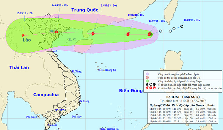
At 10 am on 9/11, the location of the center of the storm was about 20.8 degrees Vi Bac; 118.2 degrees Kinh Dong, about 800km east of Hainan Island (China). The strongest wind in the area near the storm center is strong at level 8 (60-75km / hour), level 10 jerks. The level 6 wind is strong, level 8 jerk is about 80km from the center of the storm.
It is forecasted that in the next 24 hours , the storm will move in the West, 10-15 hours per hour and there is a strong possibility. By 10 o'clock on September 12, the location of the storm center is about 20.8 degrees Vi Bac; 115.5 degrees east longitude, about 480km from Hainan Island to the East North East. The strongest wind in the area near the center of the storm is strong at level 8-9 (60-90km / hour), level 11 shock. Range of strong winds of level 6, level 8 or higher is about 110km from the center of the storm.

Movement direction of storm No. 5.
Due to the impact of storms, the North East Sea in the North East Sea has storms, strong winds of level 6-7, near the storm center passing level 8-9, level 11 jerks; strong sea.
Dangerous zone in the East Sea in the next 24 hours (strong wind level 6 or higher): North of 18.5 degrees North latitude; east of the meridian 112.5 degrees Kinh Dong.
In the next 24 to 48 hours , the storm moves in the West, about 20km per hour and there is also a strong possibility. By 10 am on September 13, the location of the center of the storm is about 20.9 degrees North latitude; 111.0 degrees Kinh Dong, right on the northeastern sea of Hainan. The strongest wind in the area near the storm is strong at level 9 (75-90km / hour), level 12 shock. Range of strong wind level 6, level 8 shock or more about 130km from the center of the storm.
In the next 48 to 72 hours , the storm moved westward, about 20km away every hour and then weakened to a tropical depression. By 10 pm on September 14, the position of the heart of the low pressure was about 21.1 degrees north latitude; 106.3 degrees east longitude, on land in the eastern region of the north. The strongest wind in the area near strong tropical depression at level 6 (40-50km / hour).
Disaster risk level: level 3.
In addition, very strong storm MANGKHUT in the Pacific Northwest sea area is continuing to strengthen, can reach super typhoon level and move toward the North Sea area in about 4 days.
- Tropical depression strengthened into storm No. 2, heading to Quang Ninh - Hai Phong
- Tin storm on the East Sea (storm No. 7)
- This afternoon, the tropical depression strengthened into a storm - the number 9 storm this year
- Tropical depression strengthened into a typhoon No. 5, heading to Binh Dinh - Phu Yen
- Tropical depression intensified into storm No. 3
- Tropical depression strengthened to No. 6, Nakri
- Typhoon Tokage jerked level 10-11 toward the East Sea
- Storm No. 14 weakens into a tropical depression
- Strong tropical depression into storm No. 1, approaching the Vietnamese mainland
- Tropical depression towards the East Sea
- Mujigae stormed near the East Sea
- Latest information about Typhoon Talim and tropical depression on the South China Sea
 Is the magnetic North Pole shift dangerous to humanity?
 Washington legalizes the recycling of human bodies into fertilizer
 Lightning stone - the mysterious guest
 Stunned by the mysterious sunset, strange appearance
 Super typhoon Manyi enters the East Sea, cold air moves slowly
  Storm No. 9 Manyi, level 12, about 200km from Hoang Sa archipelago
  Storm Tra Mi enters the East Sea today, strange movement direction
  The Da River fault zone causes earthquakes in Ninh Binh
  Sea levels are rising rapidly due to El Nino and climate change
  Tropical depressions appear into the East Sea, likely to become a typhoon