Ability to appear Storm No. 2 into the South China Sea
According to the Central Intelligence Center, on July 28, a tropical depression existed in the Eastern Philippines.

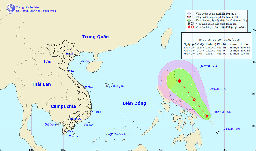
Location and path of tropical depressions.
At 07:00 on July 29 , the position of the tropical depression center was about 11.5 degrees north latitude; 127.3 degrees Kinh Dong. The strongest wind in the area near the center of strong tropical depression at level 6 (40-50km / hour), shock level 7-8.
It is forecasted that in the next 24 hours , tropical depressions will move in the northwest direction, each hour is about 15-20 km and there is also a strong possibility. By 07:00 on July 30, the position of the tropical depression center was about 14.1 degrees North latitude; 125.3 degrees east longitude, on the east coast of central Philippines. The strongest wind in the area near the center of strong tropical low pressure level 7 (50-60km / hour), level 8-9.
In the next 24 to 48 hours , tropical depressions move in the northwest direction, about 15-20km every hour, which can be strengthened into storms and towards the East Sea.
- Hurricane number 11 advanced quickly into the South China Sea
- Storm No. 13 could change direction, targeting Central
- Hurricane Kalmaegi accelerated, advancing rapidly into the South China Sea
- A strong storm of level 14 appeared in the South China Sea
- East Sea is about to have strong storms
- Super typhoon on level 17 is entering the South China Sea
- Aere storm jerks 10-12 levels into the South China Sea
- Podul storm into the East Sea, the wind 60-75km / h
- Typhoon Kalmaegi has entered the South China Sea, the country has scattered rain
- Tropical depressions are likely to become strong storms heading into the South China Sea
- Typhoon Doksuri approached the South China Sea, scattered thunderstorms
- Typhoon Tokage on the East Sea, in the South Central Coast
 Is the magnetic North Pole shift dangerous to humanity?
 Washington legalizes the recycling of human bodies into fertilizer
 Lightning stone - the mysterious guest
 Stunned by the mysterious sunset, strange appearance