Tropical depressions cause winds of level 9, Central Vietnam is seriously flooded
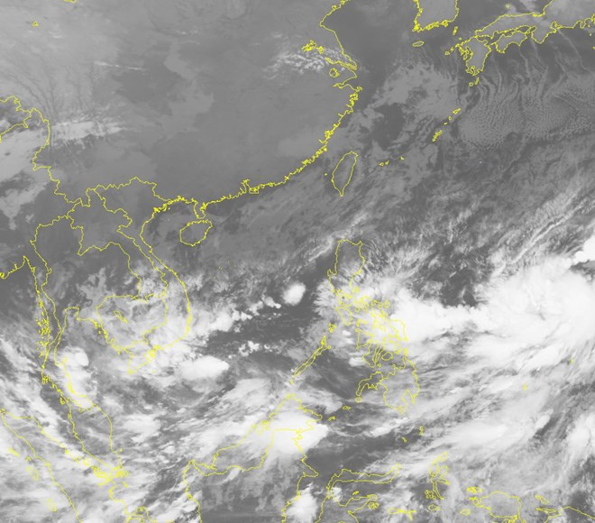
According to the Central Center for Hydrometeorological Forecasting, Tropical Depression is in the waters of Truong Sa archipelago with the highest level 6 winds (40-50km / hour), level 7-8.
Continue to move in the direction of West Northwest, forecast to November 5, Tropical Depression will be about 250km from Binh Thuan - Ben Tre coast to the East of Southeast, causing strong winds of level 6, shock level 7-9 for In the waters of the Spratly Islands, offshore provinces from Ninh Thuan to Ba Ria-Vung Tau have strong winds of level 6, shock level 7-9 and strong thunderstorms. High waves from 2-3m; rough sea.
On November 4, the area of the Tonkin Gulf came down to Quang Ngai to the north of the East Sea, the Paracel Islands got better, with only a few rain, stable wind level 4-5.
On land and thick clouds are still covering the South Central and Central Highlands provinces.
In the last 6 hours (as of 1 o'clock on November 4), provinces from Binh Dinh to Ninh Thuan have had moderate rainfall, heavy rain with 20-40mm popular rainfall, some places above 50mm such as Phu Lam (Phu Yen) 59mm, Tan My (Ninh Thuan) 57mm.

Satellite image of tropical depression.(Source: nchmf.gov.vn).
It is forecasted that by November 5, provinces from Binh Dinh to Ninh Thuan, Dak Lak and Lam Dong still have moderate rain, heavy rain, and a very big place with a total rainfall of about 50-100mm, some places over 150mm.
In addition, due to the impact of low pressure ditch connected to the tropical depression, the Southern provinces from the evening of November 4 have moderate rain, wide rain, particularly the eastern coastal area from Ba Ria-Vung Tau down. In Ca Mau, there may be places with very big rain, the possibility of dangerous events such as whirlwinds and strong winds.
The center warns water levels in rivers in Ha Tinh, Binh Dinh, Phu Yen and Khanh Hoa to slow down and fluctuate at a high level; The rivers in Ninh Thuan and Dak Lak continue to rise. High risk of flash floods in small rivers and streams, landslides in mountainous areas from Khanh Hoa to Binh Thuan and Central Highlands.
Flooding in provinces from Binh Dinh to Ninh Thuan and Dak Lak continues, especially in Tay Son, An Nhon, Tuy Phuoc, Phu Cat, Phu My, Hoai An, Hoai Nhon and Quy Nhon districts. (Pacify); Song Cau, Son Hoa, Dong Xuan, Tuy Hoa (Phu Yen); Phan Rang-Thap Tram City, Ninh Hai, Ninh Phuoc (Ninh Thuan); Mdrăk, Kông Bông, Eakar districts (Đăk Lak).
Precautions should be taken to prevent flooding affecting the safety of reservoirs in the above provinces, especially reservoirs in provinces from Binh Dinh to Binh Thuan and the Central Highlands.
In other areas, from North Central Vietnam, the weather is getting better. On November 4, the main day of the year is out, the temperature in Hue and Thanh Hoa cities is 28 degrees C.
The northern provinces are sunny, the heat will continue to increase compared to yesterday. The capital of Hanoi, Ninh Binh, Hai Phong, Lao Cai and Dien Bien Phu fluctuates at 28-30 degrees C. The cities of Lang Son and Son La are lower, only about 27 degrees C.
- Occurrence of tropical depression near the South China Sea, the possibility of strong storms
- Tropical depressions enter the South China Sea, potentially strong into storms
- Central Vietnam will have heavy thunderstorms, wind gusts to level 9
- Many central provinces respond to tropical depressions
- Saigon responds to tropical depression toward the South
- Tropical depressions may intensify into storms when approaching the Spratlys
- Tropical depressions melted, the flood in the Central region increased quickly
- Tropical depressions are gradually stronger in the South China Sea
- Tropical depression at level 8 formed in the South China Sea
- Storms and tropical depressions threaten Vietnam
- Central Vietnam faces flood again
- Tropical depressions continue to appear on the East Sea
 Is the magnetic North Pole shift dangerous to humanity?
 Washington legalizes the recycling of human bodies into fertilizer
 Lightning stone - the mysterious guest
 Stunned by the mysterious sunset, strange appearance