Danas and tropical depressions pose a third-degree disaster in the South China Sea
According to the National Center for Meteorological and Hydrological Forecasting, there are storms of Danas and newly formed tropical depressions, causing level 3 disaster risks in the Northeast Sea.
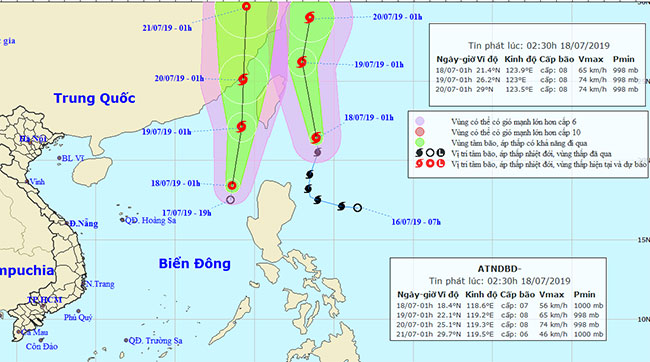
In the morning of July 18, Typhoon Danas in the sea of northeastern Luzon Island (Philippines) with the strongest wind in the area near the center of the typhoon is strong, level 10 and continues to move in the North Northwest direction.
Tropical depressions are in the Northeast Sea of the East Sea, nearly 200km from Luzon Island to the west with the strongest winds in the area near the center of the tropical depression.
In the Northeast Sea, the East Sea has rain, strong winds of level 6-7 and later rise to level 8, shock level 11, strong seas.
In the middle and southern part of the South China Sea, including the Spratlys waters with showers and thunderstorms, in the thunderstorms there is the possibility of tornadoes and strong winds; Southwest wind strong level 6, shock level 7-8, 2-4m high waves, rough seas. Level 3 disaster risk level in Northeast China East Sea.

Location and path of storms and tropical depressions.(Source: National Center for Meteorological and Hydrological Forecasting).
The hot sun in Bac Bo remained for 2-3 days; in the Central provinces, it is likely to last for many days; high risk of fire, fire in residential areas, high risk of forest fires in the Central provinces.
On July 18, the Northern region, North and Central and Central regions have hot sunshine, hot and sunny places with the highest temperature of the common day from 35-37 degrees C, there are places over 37 degrees C. Time available temperature above 35 degrees Celsius from 10-17 hours.
Detailed developments for the areas of day and night July 18:
In the north of the north, there are clouds, hot days, there are places with intense heat, evening and night showers and some places, in the thunderstorms there is a possibility of whirlwinds, lightning and strong winds. Gentle. Moisture from 45-97%. Lowest temperature 24-27 degrees Celsius; highest 34-37 degrees C, there are places over 37 degrees C.
The eastern part of the North has clouds, a hot day, heavy showers and a few places, the possibility of whirlwinds, lightning and strong winds. Southeast wind level 2-3. Moisture from 55-97%. The lowest temperature is 26-29 degrees Celsius, the highest is 34-37 degrees C.
Hanoi area has clouds, hot sunny days, no rain at night. Southeast wind level 2-3. Moisture from 57-93%. The lowest temperature is 27-30 degrees Celsius, the highest is 35-37 degrees C.
Thanh Hoa to Thua Thien-Hue has cloudy, hot sunny days, a hot sunny place, in the evening and at night there are showers and thunderstorms, the possibility of whirlwinds, lightning and strong winds. Southwest wind level 2-3. Moisture from 53-92%. Lowest temperature 26-29 degrees C; highest 34-37 degrees C, there are places over 37 degrees C.
Da Nang to Binh Thuan has cloudy, sunny days, the north has hot sunshine, evening and night showers and some places; In the south, there were showers and thunderstorms in the evening and evening, in anticipation of strong winds, lightning and wind. Southwest wind level 2-3. Moisture from 52-96%. Lowest temperature 25-28 degrees C; highest 34-37 degrees C, south 32-35 degrees C.
The Central Highlands is cloudy, rainy in the afternoon and at night, in some places with moderate rain, heavy and scattered rain with thunderstorms, in the thunderstorm there is a possibility of whirlwinds, lightning and strong winds. Southwest wind level 2-3. Moisture from 65-99%. Lowest temperature of 20-23 degrees Celsius; highest 28-31 degrees Celsius, there are over 31 degrees Celsius.
Nam Bo is cloudy, with rain and moderate rain, there are places with heavy and scattered rain with thunderstorms, in which thunderstorms can happen whirlwinds, lightning and strong winds. Southwest wind level 2-3. Moisture from 65-99%. Lowest temperature 23-26 degrees C, highest 30-33 degrees C.
- Danas storms level 10 toward the East Sea
- Tropical depressions can enter the East Sea in the next 2 days
- Tropical depressions are likely to become strong storms heading into the South China Sea
- Latest news about two tropical depressions consecutively in the South China Sea
- Tropical depressions may intensify into storms when approaching the Spratlys
- Tropical depression at level 8 formed in the South China Sea
- Tropical depressions are gradually stronger in the South China Sea
- Latest news about tropical depression
- Occurrence of tropical depression near the South China Sea, the possibility of strong storms
- Occurrence of tropical depressions in the East Sea, rainstorms all over the country
- Typhoon has just melted, tropical depressions are about to enter the South China Sea
- Tropical depressions enter the South China Sea, potentially strong into storms
- Vietnam must receive 6-7 storms and tropical depressions
 Is the magnetic North Pole shift dangerous to humanity?
 Washington legalizes the recycling of human bodies into fertilizer
 Lightning stone - the mysterious guest
 Stunned by the mysterious sunset, strange appearance